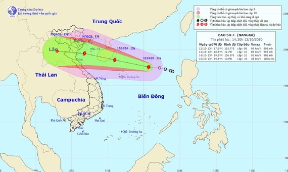
As of this early morning, the storm fizzled at around 19.3 degrees north latitude and 113.2 degrees east longitude, at 170 kilometers far from the north- northeastward of the Paracel Islands with its sustained winds of 75-90 kilometers an hour.
In next 24 hours, the dangerous system is forecast to move west-northwestward, reach 20 kilometer-hourly wind speed and continue to intensify as it will be located at the southwestward of Hainan Island (China).
By the early morning of October 14, the newly- formed typhoon will enter the Gulf of Tonkin with a maximum wind speed of 75 to 100 kilometers an hour.
It is expected that Nangka will turn into a tropical depression and low- pressure system respectively upon travelling to mainland of the southern- Red Delta and North- Central provinces.
Due to the storm circulation, the bad weather conditions of blustery winds, rough sea and big waves of 3 to 5 meters are warned for the northern part of the East Sea including the Paracel Islands and the Gulf of Tonkin from tonight.
Meantime, a range of tropical convergence connecting with an ongoing cold wave will unleash heavy rainfalls in Quang Tri and Thua Thien- Hue provinces.
From October 14-16, the storm in combination with and chilling wave are forecasting widespread rainfalls of 150- 400 mm along with thunderstorms and rain-cooled temperature of 21 to 29 degrees Celsius in the Northern and North- Central regions.
Accordingly, Nangka was the seventh named tropical storm of this year’s hurricane season.


