Deputy Director of the HCMC Planning and Architecture Department Truong Trung Kien
Based on the planning project of building embankments and improving the management of land along rivers and canals and the existing downtown area of Ho Chi Minh City in the area of around 930ha, the embellishment of Bach Dang Wharf Park in District 1 will be carried out in three phases. Bach Dang Wharf Park on Ton Duc Thang Street is one of the most popular destinations for both local residents and tourists in the central city. It covers a 23,400sq.m area and stretches 1.3km along the Sai Gon riverbank.
In the first phase, renovation and embellishment of the area of Bach Dang Wharf and preserving the Thu Ngu flagpole have been carried out so far while the city will continue to move all the hanging wires underground in Ton Duc Thang Street and underground parking and commercial areas will be constructed in Me Linh Headquarter.
Currently, the work being carried out is the first step of phase 1. In the future, when all phases are completed, the section of Ton Duc Thang road along Bach Dang Wharf will become a pedestrian space combined with the riverside park.
The renovation work is being carried out based on the planning project of the existing central zone of the city in the area of 930ha. The project has been selected for an international competition with the participation of leading consulting firms in Vietnam and in Europe, the US, Japan. The city administration has chosen the most suitable plan in combination with good ideas of other options to put into practice.
On that basis, the city approved the 1/2000 scale zoning planning project and the Regulation on architectural management of the entire existing downtown area, including specific illustrative designs for important project designs such as Bach Dang Wharf Park, Le Loi Street, Nguyen Hue Street, September 23 Park.
The system of rivers and canals are the main public spaces of town-planning compositions in the development of urban areas with rivers, and so does Ho Chi Minh City. Specifically, for Ho Chi Minh City, all general planning projects are calculated to exploit the advantages of river routes, especially the Saigon River. All zoning planning project designers have solutions for arranging landscapes and using land for parks along river banks and canals.
The regulation on the management of architecture of Ho Chi Minh City, which has just been approved by the City People's Committee under the Law on Architecture, also specifically identifies the area along the Saigon River as an area that needs specific management.
 An aerial view of Bach Dang Wharf Park in HCMC
Additionally, the city has approved the project ‘Development of river embankments and riverside service economy of Ho Chi Minh City from 2020 to 2045’ and the decision to protect the canal corridor.
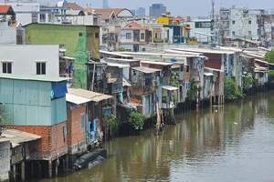
For dangerous landslide areas, the city has been building embankments at many locations to protect the riverbank along the Saigon River from Can Gio outlying district up to Cu Chi district. All major projects along the river will arrange a land fund for a green park by the river.
In general, the city is fully aware of the importance of the canal system in general and the Saigon River in particular to the city's development; therefore, the city governments have issued specific regulations, policies, and programs to protect and invest in embellishing riverside areas to serve the community.
Currently, the Project ‘Development of river embankments and riverside service economy in Ho Chi Minh City from 2020 to 2045’ approved by the City People's Committee on June 28, 2021, has been put into operation with the participation of agencies, departments of many different industries and fields and the government of Thu Duc city and districts. The implementation process is carried out according to the proposed plan. Some districts have cleared the ground and prepared to implement the plan.
According to the Project ‘Development of river embankments and economic services along the river banks of Ho Chi Minh City from 2020 to 2045’, the city will first carry out the East bank area from Saigon Bridge to Diamond Island Bridge and the river bank West from Saigon Bridge to Tan Thuan Bridge from the Kenh Te junction to Saigon River because it is an important area of Saigon River, passing through the existing cultural and historical center (West bank) and Thu Thiem financial technology and service center area (East bank).